
MetaImage
Reads and edits image metadata and geographical tags in a familiar interface


The best tool for image metadata.
All Image Formats
The app is compatible with hundreds of image formats.
Hundreds of Tags
MetaImage supports hundreds of metadata tags.
GPS & Directions
You can correct GPS locations and directions with the map.
Batch Editing
Edit multiple files simultaneously and be notified when the job is done.
Preset Support
Create and use presets to make your recurrent edits automatically.
Sidecar Support
Import and export metadata to sidecar files and CSV table.
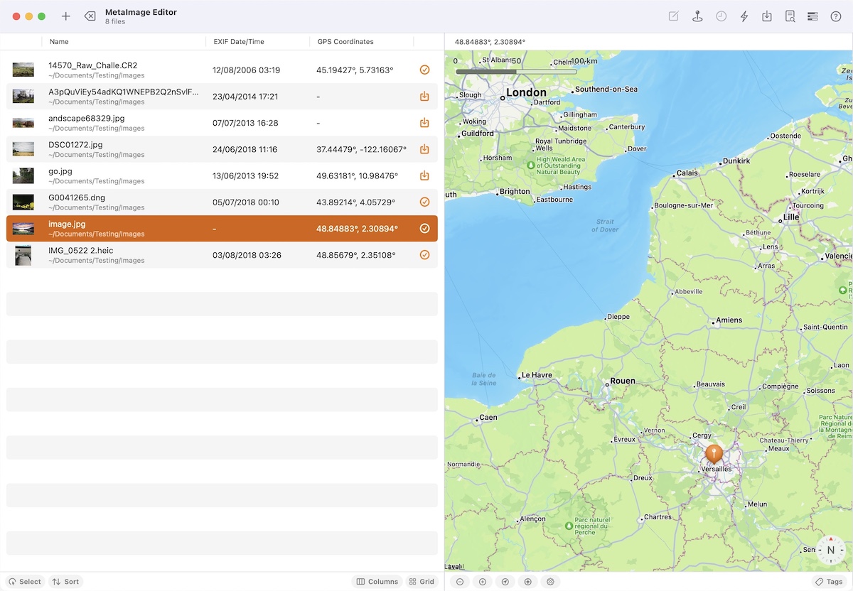
Use the map to add GPS information
Viewing and editing GPS metadata is effortless using the interactive map feature. You can easily find coordinates from addresses, and the app supports direction and altitude information.
MetaImage supports camera maker tags
MetaImage is the image metadata editor that supports the most significant number of tags. Additionally, the dedicated panel allows you to display only the tags that are most relevant to you.
Open the list of all tagsInspect and compare metadata
MetaImage offers a visualization mode to compare files, making identifying inconsistencies easy. Managing and organizing your metadata has never been easier.

A Few Key Features
MetaImage includes dozens of little features that will improve your workflow and save you time.
Photos Extension Included
The application includes an extension for Photos. You can inspect the information of your favorite shoots directly in your favorite app.
Import from Photos
The app browses and imports files directly from your Photos library.
RAW Preview
The app displays thumbnails of your RAW files, even if not supported by macOS.
Skip Loading
Import folders instead of files; this way you can skip reading metadata.
Manage your Tags
Manage the list of tags to display and keep only the ones you use daily.
Sync GeoTags
MetaImage can read your geotag files and sync the locations of your files.
Remote for Photos
A specific window is available to batch edit files stored in Photos remotely.
Get Help from the app
Do not hesitate to contact us using the feedback form included in the app.
Community driven
You can participate in the project by sharing your ideas on the forum.
Customers are loving NeededApps
With hundreds of 5-star reviews, our products have satisfied a large community.
Excellent tool to insert metadata in speed and with many valid options available, both IPTC and EXIF. Excellent support for the many fields of the IPTC standard.
If you're looking for a metadata editor, I don't think you will find one more comprehensive than this. I've been using it to tag and geolocate scanned negatives prior to importing them into the Photos app. So far I've done about 500, and it's been a very slick process.
I don’t know what happened to my first rating left here but I’ll try to repeat what I said before…this app is fantastic and the developer is very responsive. The app features a built-in feedback email tool that enables the developer to react quickly.
Download it now


